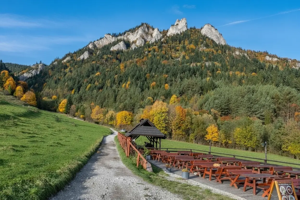
Trzy Korony, or Three Crowns, is one of the most dramatic and lesser-known geological spectacles in the Kłodzko Valley – three massive rock towers rising directly from the Nysa Kłodzka gorge, creating a spectacular landscape of Sudeten nature untouched by human hands. The name refers to the three characteristic peaks – sharply pointed summits that truly resemble kings’ crowns – and each has its own personality, its own geology, its own history of millions of years. This is where the hardness of the granite rock collides with the power of river erosion, creating one of the most amazing canyons in the Sudetes, completely different from the Trzy Korony in the Pieniny Mountains, which are well-known to tourists. The geological history of this gorge dates back 1 billion years, and each layer of stone tells a different story – from archaic granulites, through metamorphic transformations, to modern river morphogenesis. For tourists who dare to overcome difficult trails, steep climbs, and technical passages, views worthy of reward await – panoramas of the Śnieżnik Massif range, the Bystrzyckie Mountains, and the Jeseníky Mountains stretching from each of the three peaks.
Geology – Millions of Years of History Carved in Stone
Precambrian Foundations – When the World Was Young
The history of Trzy Korony begins 1 billion years ago, in the Precambrian – times when the Earth was a completely different place.
Original Rocks:
Trzy Korony are mainly built of:
Granulites – transformative metamorphic rocks that formed in the deep parts of the Earth’s crust, under enormous pressure and temperature
Gneisses – fibrous rocks formed from granites subjected to metamorphism
Amphibolites – rocks of volcanic origin that have undergone metamorphism
These rocks are extremely hard – they withstand millions of years of erosion, while softer materials around them dissolve in water and air.
Paleozoic – Sea Strongholds and Sedimentation
In the Paleozoic (500–300 million years ago), the Sudetes region was the seabed – salty waters flooded the areas of today’s Kłodzko Valley.
Sandstones, mudstones, and limestone sediments were deposited on top of Precambrian granulites.
However, Trzy Korony, being the summit of the Precambrian massif, probably protruded above the sea surfaces – they are the islands of the Paleozoic seas.
Hercynian Orogeny – Continental Collision and Metamorphosis
In the Carboniferous and Permian (300–280 million years ago), a collisionkontynentów – Gondwana and Laurasia collided, creating Pangea.
This collision caused:
Uplift of mountains – the Sudetic synclinorium and anticlinorium were formed
Further metamorphosis – rocks that had been preliminarily altered underwent further transformations
Inversion – geological maps of the entire region were reversed
Trzy Korony (Three Crowns) was then part of the anticlinorial ridge – the peak of a folded terrain.
Mesozoic to Holocene – Denudation and Gorge Formation
After the Hercynian orogeny, the region underwent denudation – erosion that gradually wore down the mountains.
The granites and gneisses of Trzy Korony resisted this erosion better than the surrounding softer rocks, therefore they stand high above the surrounding landscape.
When the Nysa Kłodzka (Kłodzko Nysa River) was formed (in the Holocene, after the last ice age), the river flowed exactly along the line of least rock resistance – between the granulites of Trzy Korony.
Over the past 10,000 years, the river has carved its bed deeper and deeper, creating today’s gorge, where the bottom is located directly next to the river’s rapids, and the walls rise 200–300 meters high.
Modern Morphology – A Paradox of Stability and Change
Today, Trzy Korony is a paradox:
Stable structures – granites and gneisses are resistant to weathering
Dynamic device – the river is constantly working, carving the gorge deeper and deeper
Erosion heads – mainly from the water side (on the river side), where the river has the greatest force
Erosion is asymmetrical – the left side of the gorge (looking downstream) may be more worn than the right, due to the curvature of the river and the Coriolis effect.
Tourist Trails – From Easy Walks to Technical Challenges
Trail 1: Hike Along the Bottom of the Gorge (Easiest)
Characteristics:
Difficulty: ⭐ (very easy)
Length: 3–4 km one way
Time: 1.5–2 hours
Elevation Gain: Almost none (mostly walking on flat terrain)
Route Description:
The trail runs along the Nysa Kłodzka river, sometimes directly by the water, sometimes a few meters from the bank.
Start: Parking lot at the mill in Bardo or Międzygórze
Route: Marked trail (usually blue or yellow)
Attractions: Views of the rock faces of Trzy Korony rising from the other side of the river, small caves, underground springs
End: Usually in Międzygórze
Ideal For: Families with small children, people with physical problems, photographers looking for views without effort
Trail 2: Ascent from Półka Skałką (Medium Level)
Characteristics:
Difficulty: ⭐⭐ (medium)
Length: 4–5 km one way
Time: 2.5–3 hours
Elevation Gain: 400–500 meters
Route Description:
The trail starts elsewhere – sometimes in Kłodzko or Bardo – and leads to the top of Trzy Korony via forest paths, sometimes steeply.
- <li class="py-0
Middle Section: Steeper, with exposed tree roots
Final Section: Technical rock climbs – tricky for those with a fear of heights
Summit: Spectacular view!
Initial Sections: Gentle ascent through the forest
Ideal For: Experienced hikers, people in good shape, lovers of mountain panoramas
Trail 3: Traversa Trzech Koron (The Most Difficult)
Characteristics:
Difficulty: ⭐⭐⭐ (difficult / technical)
Length: 6–7 km (loop)
Time: 4–5 hours
Elevation Gain: 600+ meters
Route Description:
It’s a real adventure – conquering all three peaks of the Crowns, with technical passages between them.
First Crown: The lowest of the three, but already with interesting views
Second Crown: Higher, more exposed, with steeper walls
Third Crown (Okrąglica): The highest and most beautiful – the culmination of the trip
Passage Between Peaks: Requires caution – sometimes you have to climb, sometimes descend to the saddles between the peaks (passes).
Technique: In several places, you have to use your hands – it’s not just hiking, it’s mountain climbing.
Ideal For: Advanced hikers, mountaineers, people without a fear of heights,
keen on a real adventure
Viewpoints – Where It’s Worth Stopping
Point 1: View from the Bottom of the Gorge – “Net of Heaven’s Stars”
Location: Anywhere along the bottom of the gorge, looking up at the rock faces
What to See:
Vertical Rock Walls: Rising 200–300 meters
Occult Flora: Mosses, lichens, small trees, and shrubs growing from cracks in the rock
Bird Overhead: Eagles, hawks, sometimes vultures
Sky: If you look up, the sky seems very small – the “net of stars” effect
Best Time: Early morning (6:00 AM to 8:00 AM) – light falls straight from the sky, minimal fog
Point 2: Viewing Terrace on the Rock Shelf
Location: At an altitude of approximately 750–800 m above sea level, on a steep slope leading to the summit
What to See:
Panorama of the Kłodzko Valley: The entire panoramic spectrum
The Nysa Gorge Below: The river meanders like a snake
Śnieżnik Massif: Towering in the distance like a giant pyramid
Bystrzyckie Mountains: On the left side of the horizon
Best Time: Noon – full sun, best contrast
Point 3: Okrąglica Peak – “Palace of the Sky”
Location: At the summit of the third Crown, 982 m above sea level
What to See:
Karkonosze (Giant Mountains): To the northeast, weather permitting
Sowie Mountains (Owl Mountains): To the south
Jesioniki Mountains (Hrubý Jeseník): To the west
Slovak Vysoke Tatry (High Tatras): In the far east
Best Time: Sunset – dramatic colors, last light of day
Difficulties and Challenges – What You Need to Know
Physical Challenges
Steep Approaches: Some sections of the trails reach a slope of 40-50 degrees. This requires good physical condition.
Long Distances: Even “easy” trails are 6-8 km – that’s a lot of walking.
Emotional Fatigue: After a few hours of climbing, your legs may get tired.
Weather Conditions
Fog: In the autumn and winter months, fog can completely obscure the panoramas.
Rain: The rocks become icy and slippery.
Wind: At the summits, the wind can be much stronger than at the foot of the mountain – it can blow your hat off.
Sunburn: On sunny days, the lack of shade can lead to very quick tanning.
Safety Hazards
Unacclimatized People: People with a fear of heights may have serious problems on exposed sections of the trails.
Falling Rocks: The rock walls are natural – fragments may crumble.
Unpredictable Weather: Mountain storms can appear quickly – you need to have a contingency plan.
Disorientation: The trails are marked, but it is easy to get confused in the fog.
Ecological Challenges
Sensitive Flora: The region belongs to Natura 2000 – a protected area of the European Union. Tourism must be responsible.
Wild Animals: Wolves, lynxes, foxes – you can meet them, but they are cautious.
Erosion Movements: Trails are sometimes damaged by natural processes – they may be closed torepairs.
Practical Information
How to Get There?
From Kłodzko: About 20 km south, national road No. 8 or 33
From Międzygórze: A few kilometers on foot or by car
Parking: At the mill in Bardo, at the shelter in Międzygórze, at the tourist parking lot near Kłodzko
Public Transport: Buses from Kłodzko to Międzygórze and Bardo
Equipment
Mandatory:
Solid hiking boots (not sneakers!)
Water (at least 1.5 liters)
Light jacket (weather in the mountains changes quickly)
Hat or scarf
Trail map or GPS
Recommended:
Ergonomic backpack
Camera
Energy bars / something to eat
Blister plaster
Headlamp (in case of a delayed return)
Safety
Never go in
Alone – always go in the company of at least one other person
Inform someone where you are going and when you plan to return
Wear a reflective vest (if the trail borders a road)
Respect private land – many trails cross private land